Old and new maps of West Arnhem Land
In 1922 the surveyor H.H. Kirkpatrick was asked to draw by hand a large map of the Oenpelli Aboriginal Reserve and surrounding areas.
He asked elders the names of places and he wrote them on the map the best he could.
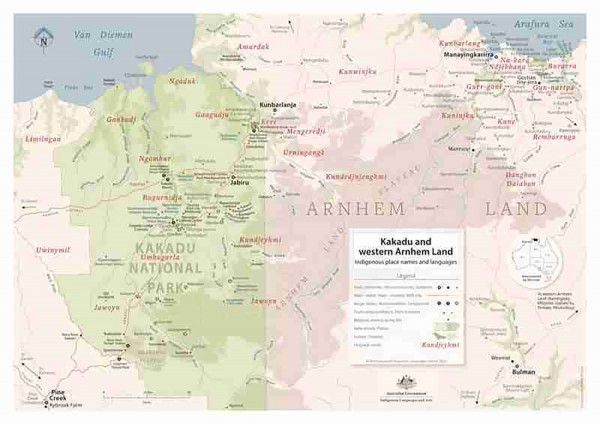
Now, exactly 100 years later, a new 2022 map of place names and languages in Western Arnhem Land has been made by the Bininj Kunwok Language Centre, using knowledge from today's elders.
If you can make it, come along to Jabiru public library at 5pm on Thursday, 17th November and take a look at copies of both these incredible maps.
You can hear some local elders talk about places whose names are written on the old or new maps. For example, on the old map underneath "Oenpelli H.S." (H.S. stands for "homestead"), you can see the name "Umblanyon" written. Where did that name come from?
Both maps are now available for the public to view at any time.
In Gunbalanya (Kunbarlanja) you will be able to see them at the Demed office.
In Jabiru they will be on display at the Library, the Council office, the Croc Hotel and Djabulukgu Association office.
They will also be displayed at Cooinda Lodge.
If you'd like to find out more about these maps, then come to the celebration, or email fieldofficer@bininjkunwok.org.au or talk to Julie Narndal or Seraine Namundja in Gunbalanya.